About samar

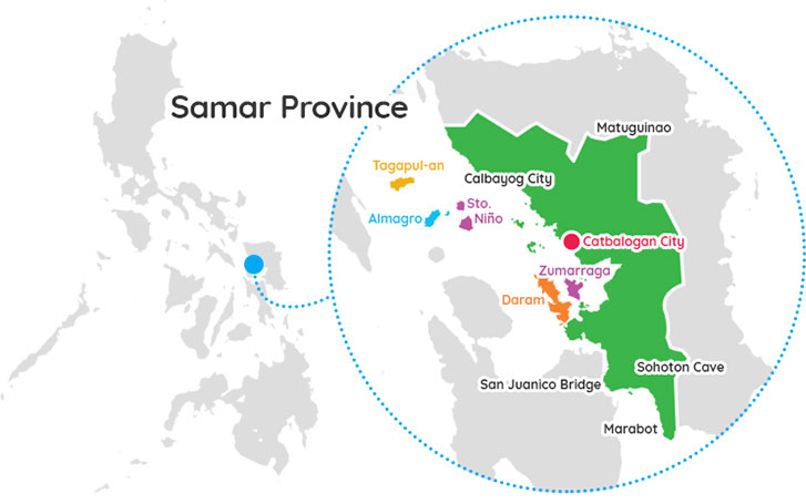
Samar, officially the Province of Samar, formerly named Western Samar, is a province in the Philippines located in the Eastern Visayas region. Its capital is the city of Catbalogan. It is bordered by Northern Samar, Eastern Samar, Leyte and Leyte Gulf, and includes several islands in the Samar Sea. Samar is connected to the island of Leyte via the San Juanico Bridge.
In 1768, Leyte and modern Samar were created out of the historical province of Samar. In 1965, Northern and Eastern Samar were created.
Fishing and agriculture are the major economic activities in the province.
On 8 November 2013, the province was significantly damaged by Typhoon Yolanda (Haiyan), particularly the towns of Basey, Marabut and Santa Rita.
Samar is said to derive from the word Samad, a Visayan word for "wound" or "cut", describing the rough physical features of the land which is rugged and deeply dissected by streams.
History
Around 2 million to 8000 B.C, based on geologic findings, during the ice ages (2 million years – 8000 B.C), the islands of Mindoro, Luzon, and Mindanao were connected as one big island through the islands of Samar, Leyte and Bohol.
In 8550 B.C., diggings in Sohoton Caves in Basey, Samar showed stone flake tools. In 1200 A.D., other diggings along the Basey River revealed other stone flakes used until the 13th century.
In 1543, the explorer Ruy López de Villalobos, first came to the island and named it Las Islas Filipinas.
In 1596, many names (such as Samal, Ibabao, Tandaya) were given to Samar Island prior to the coming of the Spaniards in 1596. The name "Samar" was derived from the local language samad, meaning "wound" or "cut", aptly describing the rough physical features of the island, rugged and deeply dissected by streams. During the early days of Spanish occupation, Samar was under the jurisdiction of Cebu.
On October 15, 1596, the first Jesuit missionaries arrived in Tinago (now Dapdap) in Tarangnan. From Tinago, the missionaries, Fr. Francisco de Otazo, Bartolome Martes and Domingo Alonzo began teaching Catechism, healing the sick and spreading the Christian faith into the interior settlements.
On June 1, 1649, the people of Palapag led by Agustin Sumuroy revolted against the decree of Governor General Diego Fajardo requiring able bodied men from the Visayas for service at the Cavite Shipyards. Like wildfire, the revolt quickly spread to the neighboring town in the Northern and Western coast of Samar and to the nearby provinces of Bicol, Surigao, Cebu, Camiguin and as far as Zamboanga. It was suppressed in 1650 by the combined forces of the Spaniards, Lutaos, and Pampangos.
In 1735, Samar and Leyte were united into one province with Carigara, in Leyte, as the capital town.
In 1747, Samar and Leyte were separated for administrative effectiveness.
In 1762, complaints from the Jesuits that the division was not working well, thus it was reunited again by the approval from the King of Spain.
In 1768, Jesuits were expelled in all Spanish dominions. The Franciscans arrived on September 25, 1768, and took over the administration of 14 of the 17 parishes which were under the spiritual care of the Jesuits for almost 172 years. The administration of the remaining three parishes namely Guiuan, Balangiga and Basey in the south of Samar were given to the Augustinians.
In 1777, the two provinces were divided for the last time, it was approved in Madrid in 1786 and had been effective in 1799.
In 1803, Guiuan, Balangiga and Basey were turned over to the Franciscans for the lack of Augustinian priests.
On August 11, 1841, Queen Isabella II of Spain signed a Royal Decree declaring Samar as a province.
The Battle of Catubig occurred on April 15–18, 1900 during the Philippine–American War.
On April 15, 1900, the Filipino guerrillas launched a surprise attack on a detachment of the US 43rd Infantry Regiment, forcing the Americans to abandon Catubig town after the four-day siege.
In 1901, the Balangiga massacre occurred during the Philippine–American War.
On September 28, 1901, the people of Balangiga, Giporlos, Lawaan and Quinapondan in Eastern Samar surprised and attacked the American forces stationed there, killing 48 American soldiers. To avenge their defeat, American general Jacob H. Smith ordered his men to turn Samar into a "howling wilderness".
On April 10, 1910, upon the papal bull of Pope Pius X separated the islands of Samar and Leyte from the Diocese of Cebu and erected the Diocese of Calbayog comprising both islands. Pablo Singzon de Anunciacion was named first Bishop and consecrated on June 12, 1910.
In 1942, the occupying Imperial Japanese forces arrived in the province of Samar.
On October 24, 1944, the Battle off Samar took place as Vice Admiral Takeo Kurita's Center Force warships clashed with several allied naval vessels in a collision course. His forces sank escort carrier USS Gambier Bay (CVE-73), destroyers USS Hoel (DD-533) and USS Johnston (DD-557), and escort destroyer USS Samuel B. Roberts (DE-413), but at a cost of his cruisers Chikuma, Chokai, and Suzuya. Despite being a tactical victory for the Imperial Japanese Navy, it did not alter the course of the Philippines campaign.
On June 19, 1965, the Philippine Congress along with the three Samar Representatives, Eladio T. Balite (1st District), Fernando R. Veloso (2nd District) and Felipe J. Abrigo (3rd District), approved Republic Act No. 4221 dividing the region of Samar into three divisions: Northern Samar, Eastern Samar, and Western Samar. Each region adopted a new capital: Catbalogan (Western Samar), Borongan (Eastern Samar), and Catarman (Northern Samar).
On June 21, 1969, under Republic Act No. 5650, Western Samar was renamed Samar with Catbalogan still as the capital.
More Provinces

romblon
Romblon is an archipelagic province of the Philippines located in the Mimaropa region. Romblon has been inhabited by aboriginal Filipinos prior to the arrival of the Spanish in 1569. Archaeological artifacts recovered by the National Museum in 1936 indicate that the aborigines of Romblon already have a rich and advanced ...read more

sarangani
Sarangani is a province in the Philippines located in the Soccsksargen region. Its capital is Alabel. Sarangani is part of the South Cotabato-Cotabato-Sultan Kudarat-Sarangani-General Santos (Soccsksargen) development cluster, and is linked by paved roads to the international airport and harbor of General Santos. The province is divided into two sections, ...read more

