About leyte

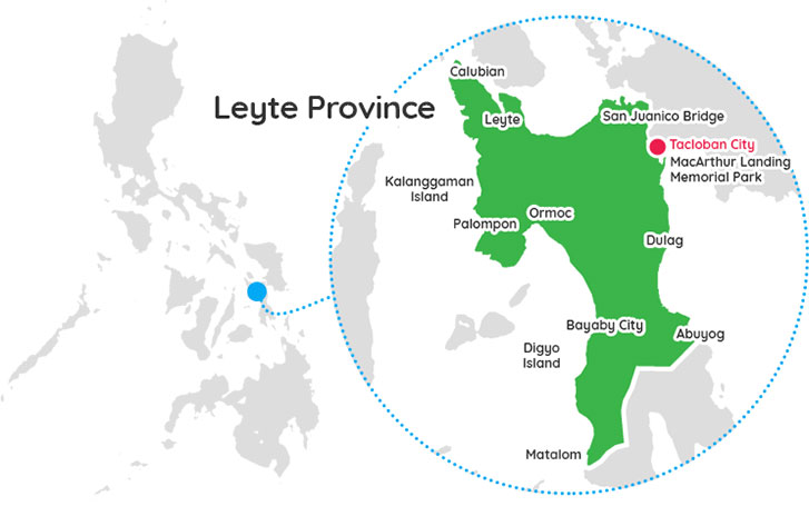
Leyte, officially the Province of Leyte, is a province in the Philippines located in the Eastern Visayas region, occupying the northern three-quarters of Leyte Island. Its capital is the city of Tacloban, administered independently from the province. Leyte is situated west of Samar Island, north of Southern Leyte and south of Biliran. To the west across the Camotes Sea is the province of Cebu.
The historical name of the Philippines, "Las Islas Felipenas", named by Spanish explorer Ruy López de Villalobos in honor of Prince Philip of Spain, used to refer to the islands of Leyte and Samar only, until it was adopted to refer to the entire archipelago.
The island of Leyte is known as Tandaya during the 16th century.
Leyte is also known as the site of the largest naval battle in modern history, the Battle of Leyte Gulf, which took place during the Second World War.
Leyte is especially prone to typhoons because it geographically faces toward the Pacific Ocean. On 8 November 2013, the province was severely affected by Super Typhoon Yolanda (Haiyan). The typhoon, known internationally as Haiyan, and domestically referred to as Yolanda, killed thousands of people and garnered significant international media attention. Leyte suffered similar destruction and loss of life in 1991 from Tropical Storm Thelma.
History
The island of Leyte was once the location of Mairete, meaning land of Ete, a historic community which was ruled by Datu Ete centered in present-day municipality of Leyte and nearby towns. It was the oldest city-state in the entire Eastern Visayas region. Before being colonized by Spain, the island was once home to indigenous animist Warays to the East and other indigenous Hindu-Buddhist Visayan groups to the west.
The Spanish explorer Ruy López de Villalobos, first came to the island in 1543 and named it Las Islas Felipinas. When the Spanish government established government in Cebu, Leyte and Samar became part of the province of Cebu. In 1595, the religious Jesuits established mission in Carigara which preceded the mission established in Palo in 1596 and Ormoc and Alangalang missions in 1597. In 1735, Leyte and Samar were separated from Cebu to be established as a single provincial government with Carigara as the first provincial capital. Leyte had jurisdiction over Samar. In 1768, Leyte and Samar were split into two separate provinces.
On March 27, 1923, Act No 3117 was proposed to divide Leyte into Occidental Leyte and Oriental Leyte but was not proclaimed by the Governor-General of the Philippines.
On May 22, 1959, Republic Act No. 2227 was passed into law that separated the third Congressional District of Leyte into a separate province of Southern Leyte.
During the World War II era, the Leyte Provincial Capitol briefly became the seat of Philippine Commonwealth Government.
The Battle of Leyte Gulf took place in the seas surrounding this island from 23 October to 26 October 1944. It was the largest naval battle in modern history, when at least 212 Allied ships clashed with the remnants of the Imperial Japanese Navy, some 60 ships, including the super battleships Yamato and Musashi.
The First Battle of Leyte occurred on 20 October 1944. A successful Allied invasion of the island was the crucial element to the eventual Filipino and American victory in the Philippines.
Members from leyte
Listings in leyte
More Provinces

lanao del sur
Lanao del Sur is a province in the Philippines located in the Bangsamoro Autonomous Region in Muslim Mindanao (BARMM) occupying the Sulu Archipelago and the provinces of Lanao del Sur and Maguindanao in central Mindanao. The capital is the city of Marawi. Lanao del Sur has a long, colourful history ...read more

maguindanao del norte
Maguindanao del Norte, officially the Province of Maguindanao del Norte, is a province in the Philippines located in the Bangsamoro Autonomous Region in Muslim Mindanao in Mindanao. Its capital is the municipality of Datu Odin Sinsuat. It borders Cotabato province to the east, Lanao del Sur to the north, Maguindanao ...read more


